
海地地震首张卫星地图发布
(单词翻译:单击)
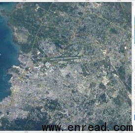
A major 7.0-magnitude震级,数量 earthquake struck the Haitian capital of Port-au-Prince on 12 January, causing major casualties and damage. The quake was followed by several aftershocks余震 with magnitudes over 5.0. Such a powerful earthquake can make current maps suddenly out of date, causing additional challenges to rescue workers on the ground. Earth observation satellite images can help rescue efforts by providing updated views of how the landscape and the infrastructure1基础设施,公共设施 have been affected2.
Following the event, the French Civil Protection authorities, the Public Safety of Canada, the American Earthquake Hazards危险,危害 Programme of USGS and the UN Stabilisation Mission in Haiti requested satellite data of the area from the International Charter on 'Space and Major Disasters'. The initiative, referred to as 'The Charter', is aimed at providing satellite data free of charge to those affected by disasters anywhere in the world.
To meet the requirements of the rescue teams in Haiti, Very High Resolution分辨率 imagery is needed from both optical and radar3 sensors4. Through the Charter, the international space community is acquiring satellite imagery as quickly as possible. Currently, data are being collected by various satellites including Japan's ALOS, CNES's Spot-5, the U.S.'s WorldView and QuickBird, Canada's RADARSAT-2 and ESA's ERS-2 and Envisat.
Satellite imagery acquired immediately after the event are used to generate emergency maps to provide rescue services with an overview6 of the current state of the area. These can be compared with situation maps generated from archived存档的 satellite data to identify major changes on the ground caused by the disaster.
Comparison of the maps from before and after the event allows areas that have been hit hardest to be distinguished7 and identify passable可通行的,可流通的 routes for relief and rescue workers. Additionally, they can help to identify areas which are suitable for setting up aid camps where medical support and shelter can be provided to people.
Radar satellites are able to peer through clouds, which is an asset有利条件 when weather conditions prevent the use of optical satellite instruments. Radar imagery can be used to identify hazards such as landslides8 that may be triggered by earthquakes. In the long term, radar data can also be processed to map surface deformations9变形 caused by earthquakes to help scientists understand better seismic10 events地震.
The Global Monitoring for Environment and Security's SAFER project is collaborating11 with the Charter to provide a specialised capacity to produce damage maps over the area. SAFER's value-adding providers SERTIT from Strasbourg and the German Aerospace12 Centre's (DLR) centre for satellite-based crisis information (ZKI) from Munich are currently working on this.
In the framework of SAFER, other user organisations, including the German Federal Office of Civil Protection and Disaster Assistance and the UN World Food Programme, have requested damage-mapping services. Based on the collaboration14 between the Charter and SAFER, the first space-maps derived15 from crisis data acquired on 13 January were produced by SERTIT within 24 hours as rapid situation maps to help locate damaged areas with up-to-date cartographic material.
Together with ESA and CNES, the Charter, founded in 2000, currently has 10 members: the Canadian Space Agency (CSA), the Indian Space Research Organisation13 (ISRO), the US National Oceanic and Atmospheric16 Administration (NOAA), the Argentine Space Agency (CONAE), the Japan Aerospace Exploration Agency (JAXA), the British National Space Centre/Disaster Monitoring Constellation17 (BNSC/DMC), the U.S. Geological Survey (USGS) and the China National Space Administration (CNSA).
Via the Charter mechanism18, all of these agencies have committed to provide free and unrestricted自由的,无限制的 access to their space assets to support relief efforts in the immediate5 aftermath余波,后果 of a major disaster.
The Charter also collaborates19 with other satellite damage-mapping initiatives within the UN such as the UNITAR/UNOSAT team who is receiving support from the U.S. government to analyse satellite imagery to be provided to the Haitian government, UN sister agencies and NGOs.
 收听单词发音
 |
1
infrastructure
|
|
| n.下部构造,下部组织,基础结构,基础设施 | |
参考例句: |
|
|
|
|
2
affected
|
|
| adj.不自然的,假装的 | |
参考例句: |
|
|
|
|
3
radar
|
|
| n.雷达,无线电探测器 | |
参考例句: |
|
|
|
|
4
sensors
|
|
| n.传感器,灵敏元件( sensor的名词复数 ) | |
参考例句: |
|
|
|
|
5
immediate
|
|
| adj.立即的;直接的,最接近的;紧靠的 | |
参考例句: |
|
|
|
|
6
overview
|
|
| n.概观,概述 | |
参考例句: |
|
|
|
|
7
distinguished
|
|
| adj.卓越的,杰出的,著名的 | |
参考例句: |
|
|
|
|
8
landslides
|
|
| 山崩( landslide的名词复数 ); (山坡、悬崖等的)崩塌; 滑坡; (竞选中)一方选票占压倒性多数 | |
参考例句: |
|
|
|
|
9
deformations
|
|
| 损形( deformation的名词复数 ); 变形; 畸形; 破相 | |
参考例句: |
|
|
|
|
10
seismic
|
|
| a.地震的,地震强度的 | |
参考例句: |
|
|
|
|
11
collaborating
|
|
| 合作( collaborate的现在分词 ); 勾结叛国 | |
参考例句: |
|
|
|
|
12
aerospace
|
|
| adj.航空的,宇宙航行的 | |
参考例句: |
|
|
|
|
13
organisation
|
|
| n.组织,安排,团体,有机休 | |
参考例句: |
|
|
|
|
14
collaboration
|
|
| n.合作,协作;勾结 | |
参考例句: |
|
|
|
|
15
derived
|
|
| vi.起源;由来;衍生;导出v.得到( derive的过去式和过去分词 );(从…中)得到获得;源于;(从…中)提取 | |
参考例句: |
|
|
|
|
16
atmospheric
|
|
| adj.大气的,空气的;大气层的;大气所引起的 | |
参考例句: |
|
|
|
|
17
constellation
|
|
| n.星座n.灿烂的一群 | |
参考例句: |
|
|
|
|
18
mechanism
|
|
| n.机械装置;机构,结构 | |
参考例句: |
|
|
|
|
19
collaborates
|
|
| 合作( collaborate的第三人称单数 ); 勾结叛国 | |
参考例句: |
|
|
|
- 上一篇:分子疗法修复酒精代谢酶
- 下一篇:佛州大鳄呼吸方式与鸟类相同


