| ||||||||||||||||||||||||||||||||||||||||||||||||||||||||||||||||||||||||
|
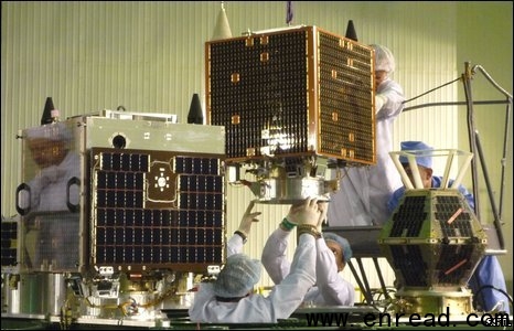
A rocket has been launched from Kazakhstan carrying two British-built satellites which will help monitor natural disasters. 哈萨克斯坦发射一颗装有两台英国制造卫星的火箭,这将用于帮助检测自然灾害。  The satellites were launched atop a converted Soviet-era missile The UK-DMC2 and Deimos-1 spacecraft will join four platforms already in the sky that together form the Disaster Monitoring Constellation1. The network obtains rapid pictures of areas struck by natural calamities2(自然灾害) - such as floods, earthquakes and fire. The imagery(肖像,比喻) is used by governments and aid agencies to co-ordinate relief. The two satellites headed for orbit aboard a Dnepr rocket which was launched from Baikonur cosmodrome(俄罗斯拜科努尔航天发射场), Russia's Strategic Space Troops said. The Dnepr, a converted Soviet-era SS-18 intercontinental ballistic missile(洲际导弹), was also carrying four other foreign satellites, including the United Arab Emirates' first space platform, known as DubaiSat-1. Map resource "After a major disaster, the first thing you need to do is supply the relief workers with an up-to-date map," explained Philip Davies, from manufacturers Surrey Satellite Technology Limited (SSTL). "If there's been a big flood, there will be landslides3, roads will have been washed away and bridges will be down. So you need a new map that shows you how to get around the area; and it's the satellite imagery that helps you do that." UK-DMC2, as the name suggests, is Britain's second contribution to the constellation(星座,星群). Deimos-1 is owned by a Spanish imaging company. The pair joins orbital assets(资产) that belong to Algeria, China and Nigeria (a Turkish satellite is no longer operational after finishing its mission). The spacecraft picture the Earth at resolutions between 4m and 32m, across an ultra-wide 600km-plus swath(一行). When they fly over their home territories, the satellites acquire a range of data for domestic use - everything from urban planning to monitoring locust4 swarms5(蜂窝), the BBC's Jonathan Amos reports. But when the platforms fly across the rest of the globe, they gather imagery which is pooled and sold on to commercial users. Every so often, however, a major disaster will strike some part of the globe and the DMC constellation will be tasked with gathering6 emergency pictures as fast as possible. Recent deployments have included the Australian bushfires in February this year, and after the major cyclone8 that hit Burma in May 2008. "The biggest use of the DMC was after the Asian tsunami9 is 2004," said Mr Davies. "We used the fact that it's a constellation and can cover very wide swaths to image the entire Indian Ocean coastline. "Other satellites may have been able to deploy7 high resolutions(高分辨率) at particular locations, but we were the only system that could cover the entire coastline at a reasonable resolution." 点击  收听单词发音 收听单词发音
|
||||||||||||||||||||||||||||||||||||||||||||||||||||||||||||||||||||||||
- 发表评论
-
- 最新评论 进入详细评论页>>


